Sunday, July 31, 2011

How long is that trail?

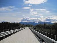
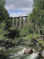
We decided to first check out the Kennecott area of Wrangle St Elias.  The road in was 90 miles of which only the first 30 were paved.  The national park is new, created around 1980, and there are no official campgrounds so we just found a side road and made ourselves at home.  The road in followed the old railway constructed to service the mine.  Because of the high ore prices and copper demand from WWI they worked on the railway all winter with temps down to -58 F .  The trestle section, that we have a picture of, contains half a million board feet of timber and was constructed in 8 days with sub zero weather.  They had to blast out holes for the foundation pilings because the ground was too frozen to dig.  I’m pretty sure somewhere in the last 100 years we have become very soft.


The next day we parked near McCarthy and walked the 5 miles up to Kennecott (or Kennicott depending on who you ask).  Kennecott is a historic mining town that the park service is in the middle of stabilizing/restoring.  Back in the day mine workers worked for $4-$5 dollars a day, had to pay the mine $30 a month room and board, worked seven days a week, and only got two days a year off.  Think how much you would look forward to 4th of July and Christmas!   And I thought that 18 days plus the 10 federal holidays was a bit low!  We then walked up to the Root Glacier, spending some time walking around on the ice.  The scale of the glacier was huge and well worth the walk, even with the 9 miles back to the car.  On the way back we swung through McCarthy and enjoyed a couple of beers with a bunch of locals, we decided that McCarthy is the Flagstaff of the north.


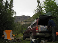
We picked up a bear can or as the park says BRFC (Bear Resistant Food Container) in Kennecott for a hike into the Nugget Creek area.  We had planned on hiking most of the way, camping, and then day hiking up the cabin and old mine at Nugget Creek but because of a missing creek we found ourselves at the end of a rather long day at the end of the trail.  In the morning the clouds had parted for the first time in a week and could see all the surrounding peaks and glaciers, including Mt Blackburn (16,390 ft).  We hiked up towards the mine and were commenting on how we hadn’t seen a bear in a while when I spotted a rather large grizzly on the trail less than 100 ft way.  Lucky for us the bear made a quick break for it in the opposite direction.  Alexis wasn’t supper happy that the bear was big enough to see eye-to-eye with her!   After that we were pretty awake and packed up our tent for hike out.  We spent the night at a RV park with a nice hot shower.  We’re now in Anchorage re-supplying and planning our next week.


Searching for Capt. Hazelwood…

We woke to a gorgeous clear day making our drive out of the Stewart area all the more impressive in that we could actually see the mountains and glaciers surrounding us.  We continued our trek north towards Alaska proper.  On our drive out we spotted the bears that were supposed to be at the bear viewing area.  They apparently didn’t get the memo and were lounging along the side of the road eating greens.  During the course of the day we saw a total of seven black bears, almost all of them chewing happily away on roadside plants.


The following day, after camping near Dease Lake, we were driving along a burned area and noticed people camped out.  We then saw a mushroom buyer and more cars parked along the side of the highway.  We decided we should see what the fuss was about and quickly, after stepping into the burnt woods, found hundreds of Morel mushrooms.  We spent the next 45 minutes excitedly picking as many choice mushrooms as we could.  We quickly realized that we might have picked more than we could deal with and left before we stuffed the whole truck full (we spent the next couple of days with the heat blasting on our feet area drying the mushrooms in our gold pans – the only real use we got from the pans).


We decided to take the road less traveled to the north and took the 300 mile Campbell Highway, 200 miles of which were gravel.   It was definitely the road less traveled, during the day and a half that we drove the gravel section we saw a total of maybe 20 other vehicles.  The views from the highway were great with lakes, rolling valleys with distant mountains, and no sight of civilization.  When we were camping we checked the time and found that we were eating dinner after 10 and the sun was still up at , a bit strange to be sitting around at with full light.  To get to sleep at a reasonable time, we velcroed our jackets to the inside of our truck shell, blocking out the light.


We stopped at Five Finger Rapid on the Yukon River where they ran stern wheelers until the road was completed in 1953.   Further north we stopped in at Dawson City and checked out the historic buildings.  The entire valley has been torn up during the gold rush days.  They ran giant floating dredges over the area and it now looks a lot like a gravel supply quarry.  The town of Dawson City was pretty touristy but the buildings were interesting.  We were surprised to find a ferry just outside of Dawson City was the only way across the Yukon.  As we were waved onto the small ferry the crewman frowned then laughed and said “at least your tires are on”; we looked back and noticed that the ferry gate couldn’t close because our truck was in the way but our tires were on…  The ferry ride was exciting, the river current was strong (5+ mph) and the “docks” were just gravel bars that they gunned the engine to keep the ferry against as cars loaded and unloaded.

Finally crossing into Alaska proper we went through the most isolated border crossing I’ve ever seen (pictured left).  Our first stop now that we survived crossing the Yukon was Chicken Alaska.  The town totaled 3 buildings with lots of chicken inspired stuff.  We had some problems getting our phones turned back on so we headed into the big town of Valdez.  The drive in was great with views of, what else, mountains and glaciers.  The town itself was about what you would expect, which is to say not all that great.  Alexis was particularly nervous of the “Man Camp” located near the airport and our campground.  We did do a nice hike along the coast and got a good view of the oil tanker loading area.  We also toured a fish hatchery where we saw thousands of pink salmon trying to get a couple hundred feet upstream from the ocean.  Next we’re headed into Wrangle St Elias national park.


Saturday, July 30, 2011

Canada - Alaska - back to Canada

After our trip around the Bowron Lakes we headed for Prince George, BC for much needed chores (everything, including us, was so smelly even the bears wouldn’t come near us).  We also indulged in some Caribou Beer and wandered around a Canadian Tire (kind of like Target on steroids).  Our planned time in Canada was getting short so we decided to start making tracks north.  The towns were getting smaller and smaller but definitely having more character.  We even got to see the world’s largest fly rod.


On a tip from a friend, we took a left and headed for Stewart, BC and Hyder, AK.  The drive in was incredible with steep mountains, tons of waterfalls, and even a few glaciers.  Ron said if you took away the snow and ice, it reminded him of Hawaii.  Stewart is a small logging and mining community with a very short but cute main street that caters to tourists.  The municipal campground provided entertainment for us.  It had been built about 20 years ago and not much had been done since then.  The trees had taken over the tent area, some of the campsite numbers were missing, and no one, including us, could figure out where our designated tent spot was supposed to be.  We checked out town and found a historic building that would have made an awesome restored hotel if there was ever a need.  It was even for sale!  One of the best features of Stewart is that you can see a glacier from town.


The next day we set out on a driving tour to the Salmon Glacier.  To get there we had to go through Hyder, AK, which touts itself as “The Friendliest Ghost Town in America”.  We made a stop at Fish Creek which the information guy promised us would have bears.  There was not a bear to be seen.  The road continued past a lot of active mining.  The Salmon Glacier is said to be the 5th largest glacier in North America and it certainly impressed us.  We got lucky with a break in the weather and we were able to see the whole glacier.  Upon reentering Canada, we were again questioned about our intentions in Canada.  It was really strange that they had a border patrol station here since you couldn’t drive anywhere but to the glacier.  From here we will continue to make tracks north.


Monday, July 18, 2011

Where’s Your Wheels, Eh?

Ron suggested the Bowron Lake canoe trip on the knowledge that his parents had done this trip "back in the day" and really enjoyed it.  We knew that permits were really hard to come by but there were a few walk-in spots available.  The rangers were incredibly helpful when we told them that we didn’t know much except that we wanted to do the trip and helped us figure the rest out.  The canoe circuit included: 12 lakes, 9 portages, and 3 rivers for a total of 22 miles hiked and somewhere around 65 miles paddled.  We decided to forego the wheels that everyone was using to transport the canoes and carry our gear and canoe ourselves.  We carried our gear, stashed it in bear boxes at the other end of the hike, hiked back for the canoe, and then carried the canoe across the portage route.  In the first part of the trip, we were surrounded by very green rolling hills.  There were a few marshy areas to paddle through with very green grass.  We were told that it had rained for two weeks straight prior to our start date, but we were lucky and had blue skies with a few clouds.  The first day we completed the three longest portages and settled into a camp on the longest lake on the circuit.  We also looked awesome with our heads inside the upside-down canoe.


We paddled the next few days on Isaac Lake and were joined at a few camps by other groups.  One rather large group did not find room at the group camp and joined us.  Even though there was only 1 tent site (surrounded by rushing streams), there was also an old trappers cabin that the park had kept around for the circuit and the group tucked in around this area.  They all came one by one to chat with us and were really happy to find space.  In return, they shared some fresh duck eggs and bacon for breakfast!  Isaac Lake was also reputed to have some good fishing and Ron proved that rumor correct catching a 17” rainbow trout. 


The exit for the lake was down the Isaac River where we got to run “the chute” and “the rollercoaster”.  Both were pretty fun and with the high water, we even had some waves.  The route demanded two portages around the cascades and the falls.  We camped that night at a single tent camp with Lake Lenazi lapping at our tent site.  This area offered great views of steep mountains, an ice field, and even a glacier.  From here we floated down the Cariboo River and did a short hike to rather impressive water fall.  We also completed the last three portages and moved out of the mountain area and back into the rolling hills.  Everyone we had talked to had told us that the Bowron River would be absolutely teeming with moose so we planned to get up super early in the morning to increase our chances of moose viewing.  After floating down the whole river and poking every side channel, we still had not spotted one.  We were starting to loose hope when the river opened up to a large grassy area and we immediately spotted 5 moose!  Ron was super tough and carried the canoe solo for half of the portages (super tough!).  We are now in Prince George and plan to get to Alaska by the last week of July.

Sunday, July 17, 2011

So, It Can Snow Anytime of the Year, Eh?

Oh, late spring, why do you make things so tricky?  We pounced Banff and found that, once again, all of the higher elevations we wanted to backpack were covered in snow.  The park information referred us to a two night backpack trip on Lake Minnewonka.  It was pretty popular for the first few miles, but thinned out rather quickly.  Ok, we were the only ones on the trail.  The trail followed the shoreline of the lake with beautiful views of the rugged mountains around.  We spotted a momma black bear and two cubs.  The momma was showing the wee ones how to pull bark off the downed trees and go for grubs.  Mmmm…  This was supposed to be the beginning of high season but we found ourselves with the camp to ourselves for the two nights.  We did a day hike from our campground and found several lakes and streams that were a beautiful blue color from the glacial till in the water.  We also found a boy scout camp and a dirt road and quickly retreated to our peaceful camp. 


From Banff, we headed north along the Icefield Parkway.  It was one of the most incredible drives that we have done so far.  Along the way we did a couple of short hikes and saw hanging glaciers, huge ice fields, and rivers moving quickly (and deathy) through narrow slot canyons.  We found a great camp site that only allowed tents and had some great shelters in case of rain…or snow.  We decided to stay two nights since there were some hikes around and the Columbia Glacier was nearby.  We had seen a road sign warning that it could snow at any time of the year and thought somehow since it was July that it would be safe to giggle in the sun.  Our camp had a view of the Columbia Glacier and more than a few mosquitoes.  That night and the next day we really learned to appreciate the shelter with a wood burning stove and experience a rain/snow mix in July.  We made the trek to the glacier and were soaked within a half hour.  That morning we had shared the shelter with a really nice family and decided to head back to the warmth and enjoy some reading, tea, and dominos.  The following day was the same weather so we decided to head north into Jasper.


In Jasper we found Athabasca Falls and Mount Edith Cavell.  The falls were incredibly powerful and followed a narrow canyon.  At Mount Edith Cavell we found several trails that offered great views of 3 different glaciers along with a glacial lake.  As with all the glaciers in this region, the glaciers have been in rapid retreat since the late 1800’s.  We thought we would do another backpack trip but once again the snow and little trail information deterred us.  After consulting the rangers and a few maps, we decided to head for the Bowron Lakes for a week long canoe trip.