Monday, May 23, 2011

The White River Expedition

We rendezvoused with our friends Taylor and Amy at our other friends Rob and Betsy's house in Boise.  We briefly discussed our travel plans and the all headed downtown to sample the local beers and get some dinner.  We returned to Rob and Betsy's house for some awesome rhubarb and strawberry pie.  Unfortunately Rob had to get to the airport by 5 the next morning so after staying up a bit later than we should have (especially Rob) we turned in for the night.  The next morning we got our shopping done for the next week and headed south towards Utah.  We spent the night at Massacre Rock State Park, a really nice park right next to the Snake River.  The weather was turning cold again so we headed farther south into Utah, stopping Lava Springs for a picnic lunch.  After driving most of the day we found a campground near Flaming Gorge.  Unfortunately for us the rain had followed, but fortunately for us we started our fire just in time; you can see us in the photo below really enjoying ourselves.  I woke up when the patter of rain stopped and looked out to see that the rain had been replaced by snow... 


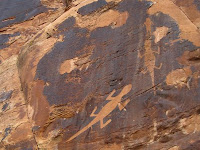
After some discussion and investigation of the weather report we decided to head further south and to lower elevation, postponing our intended Flaming Gorge float trip.  Stopped in Vernal for some information on Dinosaur National Monument but no one there was much help so we just headed for the park.  We didn't see any dinosaur bones but we found a nice camp along the Green River with lots of hiking possibilities.  Because of the weather not being terribly well suitable for a river trip we instead spend two days in the park hiking around.  We did a nice loop hike up a anticline and visited an old ranch that was run buy a woman named Josie from around 1910 to 1950.  She seemed like a pretty wily woman.  After our turn in Dinosaur, and with the weather still a bit cold, we decided to not do the Flaming Gorge trip but to instead do a trip on the White River.


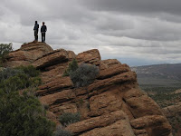
We had learned about the White River while trying to get information on Dinosaur in Vernal.  We planned a two night, three day, trip starting near Bonanza Utah (go ahead and try to find it on a map).  We camped at the put in and launched early(ish) the next day in good weather.  The river passed through some amazing country with steep canyon walls and few signs of people.  In fact we only saw one other group in our three days.  Our second night camping we hiked to Goblin City, which was described by men on one of Powell's expeditions, and were enjoying the view until the clouds rolled in and my hair started to stand up.  Taylor and I decided to make a hasty retreat.  Amy and Alexis saw us coming down the hill and, not waiting for us, ran down as fast as they could.  A minute later there was a pretty good bolt in the area and then it really started to rain.  We took shelter under some ledges but it wasn't the driest place I've ever been.  The rest of the night was stormy, with only a short break in the weather during which Alexis cooked us a great baked pasta dish. 
By nine the following morning there wasn't a cloud in the sky and we enjoyed a leisurely drift down the river...until a little cloud was joined by a couple more and pretty soon we were paddling hard towards the take out to beat the looming storm.  Made it just in time and, after packing up, drove through a wind/sand storm back to Vernal where we are now.  Tomorrow we're gearing up for our float trip down the Green in Desolation Canyon.


Sunday, May 15, 2011

Its Raining Quads!

 After a great week of relaxing and reorganizing at Ron's parents (thank you again!) we headed for eastern Oregon.  Turns out we are still on the winter side of spring and the Cascades had a fair amount of snow.  With hiking and backpacking out, we headed for lower elevations.  Our first stop was the Metolius River where we fed fish of various sizes at a fish hatchery.  It was really entertaining to throw food into the areas where there were no fish and watch them race.  There was a very lucky bald eagle perusing the lake for a tasty fish snack.  We also checked out the spring-fed headwaters of the Metolius. It was quite impressive! 


 We headed deeper into eastern Oregon and checked out the John Day Fossil Beds.  There were a lot of great short hikes with beautiful vistas.  They had a new visitors center that contained a lot of information on the local geology and displayed various fossils found in the area.  We spent the night along the south fork of the John Day River where we planned on doing an overnight backpack trip the following day.  The trail immediately crosses the river and follows a canyon.  As it turns out, being a very late spring, the river was quite swollen and, even though we have extensive stream crossing experience at this point, it proved to be too much for us. 


Redirecting our adventure once again, we headed to a reservoir on the Snake River along the Oregon/Idaho border.  Turns out being spring, they had let a bunch of water out of the reservoir and it didn't look appealing for a canoe trip.  It's a good thing that we are not terribly skilled at planning because we would not be able to stick to any plans at this point!  We decided to follow a small dirt road up a drainage and look for some camping.  High mountains and snow must be our native habitat because we once again ended up on top of a mountain at snowline.  It was one of our more scenic camps to date.  Hiking through the snow if flip flops, we discovered a couple sets of bear prints and possible wolf tracks.  This made me a bit nervous to be sleeping with our topper hatch open, especially since there are ~15 pounds of granola under us.  We watched a huge storm roll through the area that night with TONS of lightning. 


We headed to Boise to meet up with our friends Taylor and Amy.  They were not meeting us until the following day so we found some hiking and camping close to town.  We did a 7 mile hike that Ron told me was only 3 and then settled into the back of the truck to relax and do crosswords.  This area has a pretty extensive trail system where the trails are divided for different uses.  There were a lot of motorcycles and quads in the area.  As we were doing crosswords, we learned first hand how the gene pool can be self-limiting and that quads really are dangerous.  Who knew!?  A quad came ripping around the corner and, due to lack of common sense and ability, did approximately 4 cartwheels, coming to a rest upside down.  All this happened about 20 feet away from where we were sitting.  Ron ran over to find the dude unresponsive and I called 911.  After several minutes, the kid came to and told Ron he was 14.  He then proceeded to take off his helmet where he found a good handful of gravel shoved up there.  His dad showed up, was extremely concerned about the condition of the quad, and told us to cancel the paramedics.  Seeing that he was in good hands, we retreated back to our crosswords.  Needless to say, it was pretty exciting and we now feel in touch with the local culture. 

In an effort to find warm weather and no snow, we are heading to northeastern Utah to do some river trips and hiking.  The weather report shows cold and snow in the Utah area for the next week...


Tuesday, May 10, 2011

Waiting for Spring

After finishing our hike on the lost coast we headed north planning on spending a week or so making our way to Corvallis to visit with my parents.  We soon discovered two things; the first being that spring had not fully arrived to the northern California Coast, the second was that Alexis had contracted a rather good case of "mystery rash" on her arms and legs.  We drove along the coast through the town nice town of Ferndale and then on to Eureka where Alexis, sporting her now rather alarming rash, go us a deal at a hotel by saying that her mean husband was going to make her camp out in the woods if the hotel was too expensive (this might of been true).  We went and located some Tecnu (poison oak wash) and Mexican food and called it a night.  The following day we drove through, and hiked in, the redwoods and then drove into Oregon where we found a great free campsite with a picnic table next to a stream.  We made a great dinner and had a fire (my wet-wood fire starting skills have greatly diminished from my time in Arizona).  


The next morning we headed to Bandon and stopped for a couple of nice walks on the beach.  Walked around the town of Bandon and found chocolate covered blueberries and some pretty good fish and chips.  Alexis's rash was continuing to get worse so we kept stopping in all the drug stores to try and find some Zenfel (the stuff is $40/oz but is supposed to work wonders on poison oak).  We had no luck finding it and spent the night camped on an old logging road in the hills.  It was a rainy night with lots of mosquitoes so we turned in early.  After checking 5 pharmacies in Reedsport we finally located the Zenfel.   We where going to do some hiking and possible backpacking in the Oregon Dunes but Alexis's rash kept getting worse and it was raining so we took a walk on the beach and drove up to Newport for some clam chowder at Mo's (if you click this link be prepared for some pretty sweet music!)  and some beer over at the Rouge Brew House.  We decided that, because of the weather and rash situations, we would head over to my parents house a couple of days early and reorganize our truck and rest up. 

At my parents house we unloaded our truck and started buying all the supplies that we might need to get to Alaska and back.  I made a big batch of pancake mix and then in the same spirit made some granola.  I decided that a quadruple batch of granola would be best, so after several hours we were the proud owners of 15+ pounds of granola...I think we'll be pretty sick of granola before we're through.  The Zenfel really didn't do much, if anything, for Alexis's rash so after wasting hours trying to locate a Urgent Care center and talking with our insurance company, who clearly stated that they would not cover any Urgent Care centers in the area, we headed off the the emergency room (maybe this is why health insurance is so expensive!).  The doctor, of course, told us what we already knew "contacted dermatitis of unknown origin" and wrote a prescription for oral steroids that cost us a whopping $2.21.  She seems to be healing up now but I'm nervous waiting for her to flip out in a "Roid Rage".

With my parents we went up to the Evergreen Aviation Museum to check out all the planes they have and look at the Spruce Goose.  The museum was really nice and the Goose is incredibly large.  On the way back to Corvallis we hit a couple of wineries for tastings.  We had a great time with my parents and are now fully stocked and reorganized (I'm not sure if we could fit any more food in our truck if we tried).  We are headed across Central Oregon to meet or friends Amy and Taylor to do some canoeing/hiking/rafting on the Green River where hopefully the weather is warm!


Saturday, May 7, 2011

We continued the journey up the California coast over the Golden Gate Bridge and followed the very scenic Highway 1.  The coast had a great county park system with a lot of trails and we found an 8 mile loop on top of a bluff right next to the ocean.  We also did a driving tour through Mendocino which is unbelievably cute even though it is a bit yuppie.  Camping was a bit expensive but luckily a local filled us in on some free camping next to a river and reservoir.  We found a great spot right next to the river surrounded by huge redwood trees.  It rained a little bit overnight and the next day we got to figure out exactly how deep puddles can be and still be able to drive through them.  We took a scenic logging road tour and found ourselves in Fort Bragg at the North Coast Brewing Company for some onion ring and nacho carbo loading before the big backpacking trip.  While we were there, we got in touch with our friends Shayne and Greg who were also doing a tour of the California coast but heading south.  We all decided to meet in Shelter Cove for a night of camping, wine, and smores!  The really crazy part of this meeting was that we also saw these guys in the Florida Keys around Christmas time.  We think that they are stalking us...


Once in Shelter Cove, we located our trail head and packed up for the big hike along the Lost Coast.  We planned four days and three nights to do an out and back hike of 52 miles.  Ron did research for his undergrad senior thesis in this area looking at Holocene marine terraces.  This is the longest section of undeveloped California coast due to very steep terrain and landslides.  The majority of the hike is along the beach with loose sand, boulder hopping, and two sections that can only be accessed during low tide.  The remainder of the trail was on top of the terraces.  Luckily our timing was perfect and we discovered fields of poppies and wild iris.  Our first day was a long 14 miles and we were pretty tired by the time we found our camp.  I never thought I would be hungry enough to eat macaroni and cheese with tuna wrapped in a tortilla.  Absolutely delicious.  The next morning we sat by the creek that ran right next to our tent.  An otter came swimming out of an ocean wave, walked along the beach toward us, and then proceeded to swim up the creek.  Who knew they could do that?!  Ron also discovered bear and coyote prints on the beach.  The next day we set out for Sea Lion Cove.  The huge rocks exposed in the ocean were literally covered with sea lions, all of which were howling very loudly.  We found a sweet camping spot on top of a bluff and Ron, using all of his Grand Canyon experience, tied our tent down so that it would have taken a 50-60 mph wind to remove it from the bluff.  From here we continued north to view a lighthouse and check out the north end of the trail.  The scenery was outstanding!  Steep green rolling hills and sand dunes next to the ocean.  As the wind proceeded to pick up, we decided to head back to our camp. 


A few brief rain showers made their way through as we cooked breakfast and had coffee but then the weather cleared.  Shayne had told us that the whales were migrating along the coast this time of year so we kept our eyes peeled.  With the sun out, we spotted a whole pod slowly making their way up the coast.  After breakfast we headed south once again.  The tide was still a bit high and made some of the hike pretty exciting.  There were a few places where we had to time the waves in order to get around a corner.  The ocean was definitely nipping at our toes.  We made it to a campsite along a creek south of where we had camped the first night and left only about 6.5 miles to get out the next day.  Distance was really hard to judge along the coast.  We could see Shelter Cover and it looked really close but it still took as about three hours to finish the hike.